
Environmentally friendly winter sports
The initiative ‘Nature-friendly mountain sports in Montafon’ originated in winter – when the pressure on sensitive habitats is particularly evident. This is because wild animals are especially sensitive to disturbances during the cold season, and forests and soils are also in a vulnerable dormant phase.
The aim of the initiative is to enable winter sports away from the slopes in harmony with nature and habitats – through dialogue, awareness raising and concrete solutions on the ground.
Rules in the free ski area
Wildlife sanctuaries, hunting reserves, young growth areas – with so many different regulations, it's easy to lose track of what's what. To ensure you're always safe when touring off-piste, here's a brief summary of the applicable regulations.
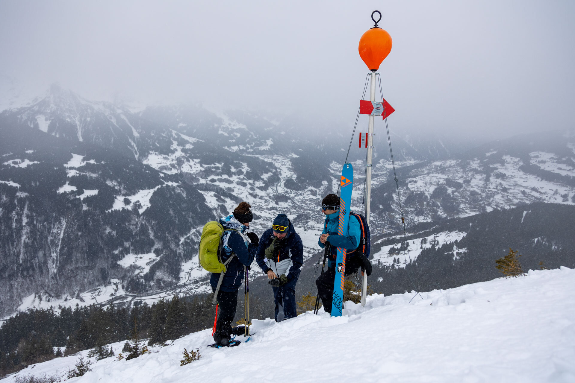
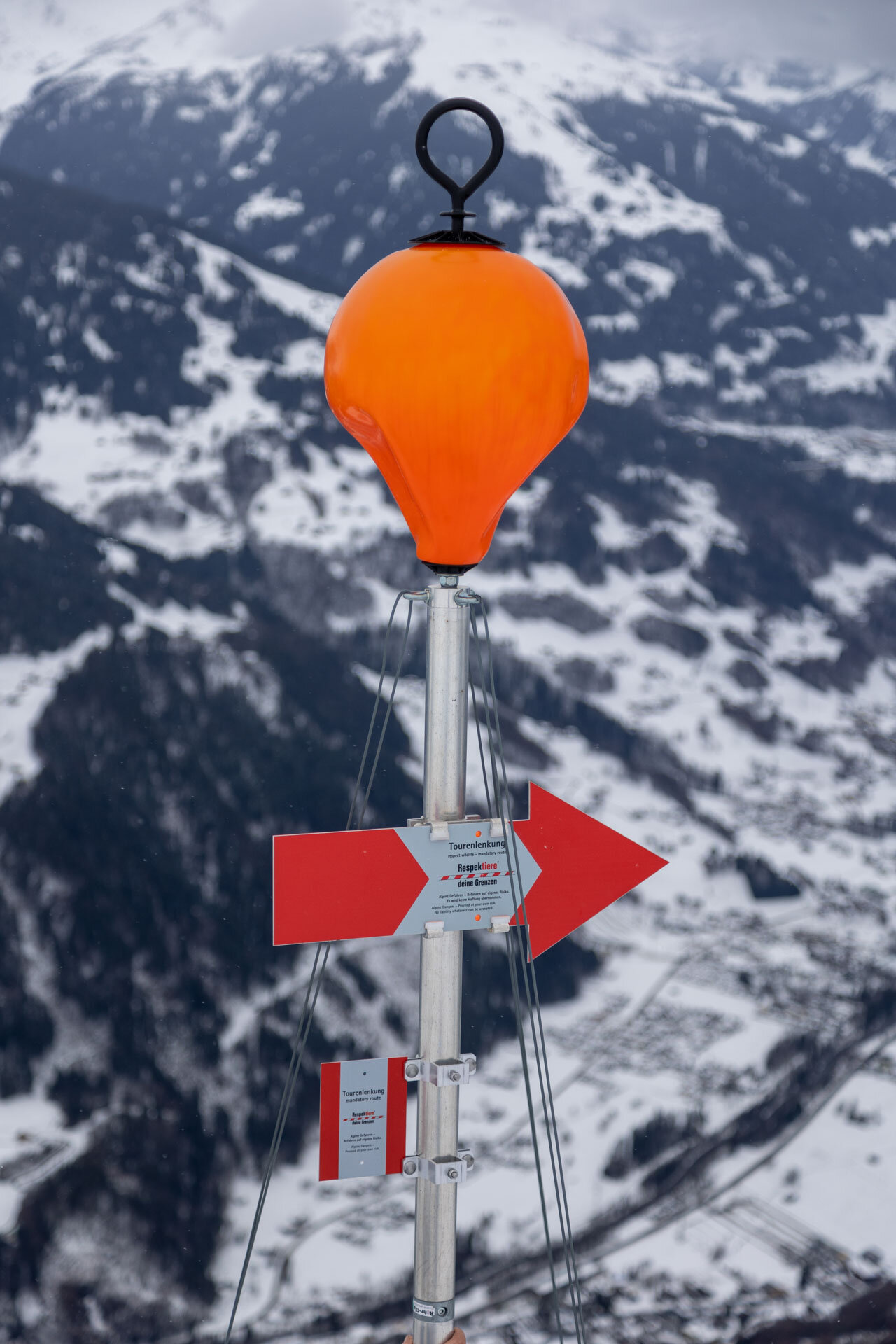
Skiing in open terrain
Outside of forest areas, winter sports equipment may be used if there is sufficient snow – as long as the areas are not fenced off or closed off by signs such as ‘Respect your boundaries’ or other measures.
Wildlife sanctuaries, hunting reserves and other protected areas
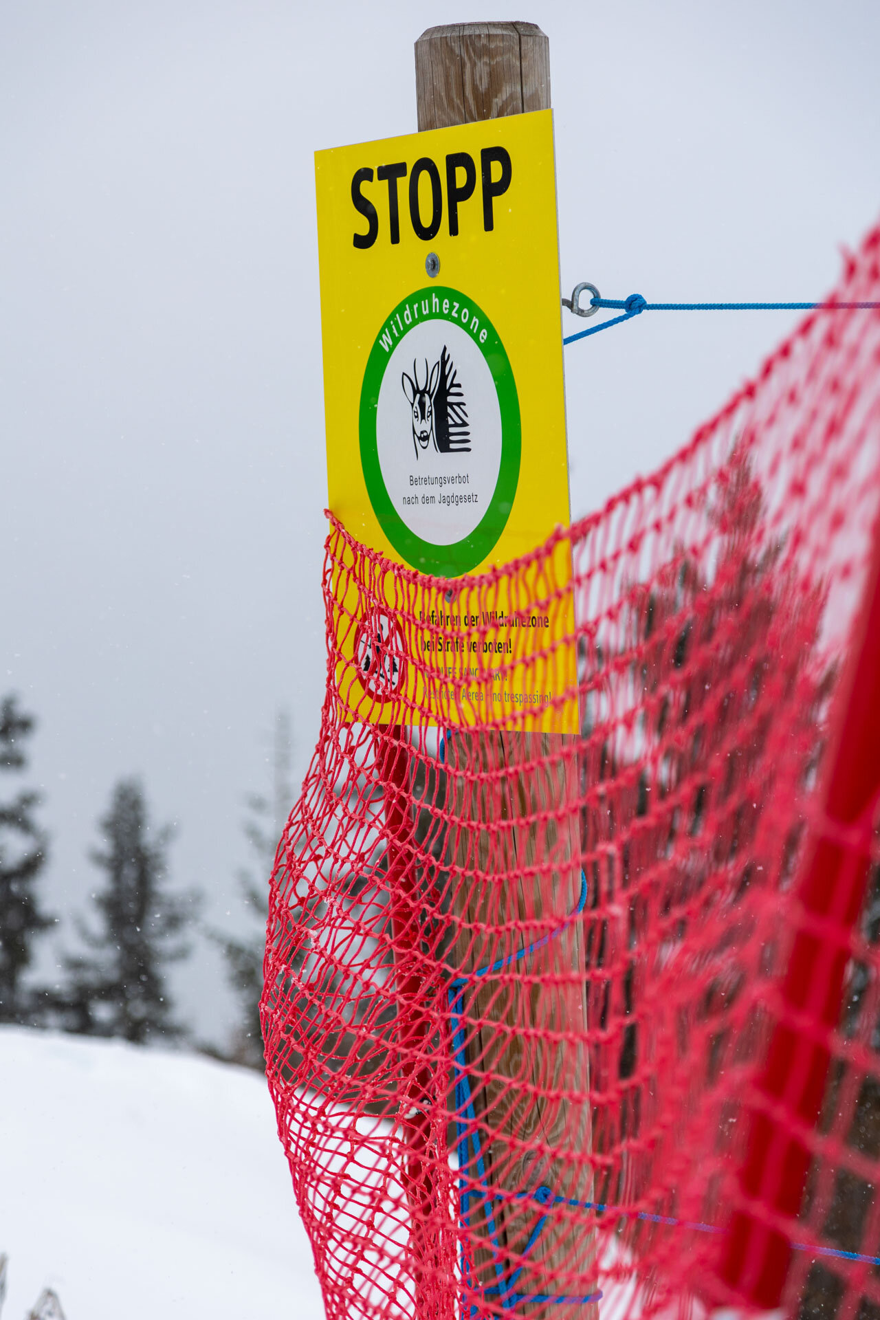
Wildlife rest areas are intended to preserve refuges for our wild animals in areas that are particularly prone to disturbance. In these sensitive areas, there is a general requirement to stay on the paths. Snowshoe hikes and ski tours may therefore only be undertaken along designated roads and paths. Feeding wildlife is to be avoided within a radius of 300 metres.
Wildlife rest areas and hunting reserves are specially marked with green signs.
In addition to wildlife rest areas and hunting reserves, there are other protected areas with relevant regulations for winter sports, such as the ‘Verwall’ European protected area or the ‘Vergalden’ rest area.
Downhill runs in the forest
In general, there is free access to the forest. However, in the area of climbing aids* or lifts, skiing in the forest is only permitted on marked slopes and ski routes. Young growth areas with vegetation less than 3 metres high may not be entered. This ensures new growth and reforestation.
Please note that the above regulations do not require any special signage in the forest.
*The ‘area of ski lifts’ refers to the distance that can be reached from the top station of a ski lift without having to walk for thirty minutes, but in any case an area of 500 m on both sides of the ski lift, piste or marked downhill run.
Forest wildlife sanctuaries
For selected areas in Montafon and Klostertal, user groups, landowners and managers have agreed on areas that winter sports enthusiasts should avoid in order to protect forest areas and wildlife. These so-called forest and wildlife conservation areas are intended to ensure that areas can continue to be used for winter sports in general.
By complying with these agreements, you too are helping to preserve the habitat of wildlife and forests.
IMPORTANT: Compliance with the agreements is continuously evaluated and changes may be made for the next season if necessary. Please keep yourself informed!
Maps
You can find a map showing all designated wildlife rest areas, protected areas and restricted areas in the Vorarlberg Atlas.
Information
Further information on how to behave appropriately in nature can be found at www.respektiere-deine-grenzen.at.
Current project areas
The provisions defined in the individual working groups for the respective areas are based on the following principles:
- Regulations stipulated in accordance with the Vorarlberg Hunting Act (game reserves, hunting restrictions), the Act on Nature Conservation and Landscape Development (protected areas) and the Federal Forestry Act (young forest areas and skiing in the forest)
- Voluntarily agreed restricted areas which, with the exception of paths and roads, should not be entered or driven on during the winter season (forest wildlife sanctuaries).
1. Muttwald
A management concept has been in place for the Muttwald forest for several years now, developed in collaboration with the Austrian Alpine Association. In the period from 1 November to 30 April, the "Muttwald" wildlife rest area is only open for winter sports along the designated corridor. Information boards are located at the Kristbergbahn valley station, along the ascent route and at the summit of the Muttjöchle. Individual orientation aids can be found along the corridors.
2. Gretsch
For ski tours in the area of Alpe Gretsch (Lobspitze, Fellimännle), ski down the forest path from Alpe Gretsch into the Wasserstubental valley or further into the Silbertal valley without exception. All tracks and avalanche gullies leading into the Wasserstubental or Silbertal valleys should be avoided, as should the areas of Alpe Gretsch close to the forest. Please pay attention to the orientation aids in the terrain.
The entire area - parts of which are located in the Verwall Natura 2000 area - is of great importance for our native wildlife species, especially for grouse such as black grouse and ptarmigan. Please be considerate of the needs of these species, which are sensitive to disturbance.
Natura 2000 area information on respektiere-deine-grenzen.at
3. water tube valley
Forests and forest edge areas are frequent habitats for wild animals and should therefore be avoided, especially in the vicinity of the Sonnenkopf ski area (the ban on vehicle access according to the Forestry Act applies here) and between Hochburtscha and Fellimännle (see also Gretsch tour guidance). Please note the marked retreat areas for chamois, snow grouse and black grouse in the European nature reserve "Verwall".
Natura 2000 area information on respektiere-deine-grenzen.at
4. Fredakopf and the Verwall European nature reserve
The Verwall European nature reserve or Natura 2000 area is the largest protected area of its kind in Vorarlberg. Here, shy animal species in need of peace and quiet can still find large undeveloped areas that allow them to survive without disturbance - especially during the winter months when food is scarce. To protect wild animals, direct off-piste descents from the Fredakopf mountain station on the Hochjoch (Silvretta-Montafon ski area) into the Silbertal are prohibited. This also applies to forest-free areas. When ski touring, pay attention to the closed areas, descents are only possible via forest and goods roads.
Natura 2000 area information on respektiere-deine-grenzen.at
5. Hochjoch
East of the Kuhtäli on the Hochjoch is the year-round wildlife rest area "Mittagsjoch". When driving through the Kuhtäli or the adjacent Schoftäli, make sure that you change to the goods road before the Alpe Platina and do not drive any further.
6. Matschun - Garnera Valley
In the Matschunertobel area, the descent into the Garneratal valley is via the immediate vicinity of the summer trail. The south-east facing slopes between the Matschuner Joch, Versettla and Lifinar/Burg are to be avoided in any case.
Please remain calm in the vicinity of feeding stations and keep the greatest possible distance.
7. Burg
In the Matschunertobel area, the descent into the Garneratal valley is via the immediate vicinity of the summer trail. The south-east facing slopes between the Matschuner Joch, Versettla and Lifinar/Burg are to be avoided in any case.
Please remain calm in the vicinity of feeding stations and keep the greatest possible distance.
8. Vergalda
The "Vergalda" rest area is an important retreat for our native wild animals. The following regulations apply:
- The area around the Edelweisswände and the Ritzenspitzen must be avoided all year round; there is a general ban on entering the area.
- The area between Ritzenspitzen and Valzifenzalpe may not be entered between 1.11 and 31.05.
- Flying with manned or unmanned aircraft (drones, paragliders, etc.) within a height of 300 m above the terrain is prohibited in the entire valley.
- Camping and bivouacking are not permitted in the protected area.
9. Valisera
In Valisertal, a general ban on trails applies in the area of the wildlife rest zone from November 1st to April 30th. Ski tours and off-piste descents in the Valisera Valley are therefore prohibited until further notice.
10. Wang
In the area of the "Wang" variant descent, attention must be paid to the existing "Lifinar" wildlife rest zone (October 15 to April 30). A narrow, passable corridor is marked by a corresponding orientation aid in the terrain. The areas below the forest road (connecting road to the Kropfen/Zamang mountain station) must be avoided without exception.
11. Ronawald (Golm)
A ski route (no. 22) has been set up on the Golm into the Gauertal. The ski route leads through the Ronawald wildlife rest area (November 1 to April 30) and may therefore not be left.
12. Platzis
For ski tours in the Kreuzjoch area and descents via the Platzisalpe, the corridor or route via the Platziserzipfel should be chosen. Other corridors and slopes in the area of the Golmerbach are reforestation or young growth areas and should therefore be avoided. The further descent to Vandans via Ganeu must be made exclusively via the forest road.
Also to be avoided is the path from Innergolm/Schandang in the direction of Tschöppa (Roteböda). Here there is a reforestation area of the torrent and avalanche control.
The entire area is an important habitat for wildlife, especially for grouse species that are sensitive to disturbance!
13. Glattingrat
The variant descent from the mountain station of the Glattingratbahn (Sonnenkopf ski area) into the Verwall European nature reserve (Nenzigasttal) is permitted along designated corridors . These run via the Alt-Maisäß and the Kuhtäli and the area north of the Rinderberg. An overview of the corridors can be found on the information board near the mountain station. The descent is at your own risk (free ski area, no ski route) and is only recommended if you are familiar with the area and terrain. The corridor in the Alt-Maisäß area (right-hand corridor on the map) was cleared at the end of 2018 to make it easier to ski down. Stay on this corridor if possible.
In the Nenzigasttal valley, always take the forest road to Langen am Arlberg. The forest areas are important retreats for wild animals, especially for grouse such as capercaillie, hazel grouse and black grouse.
Natura 2000 area information on respektiere-deine-grenzen.at


Drones flying in Montafon
Drones are popular for recreational use – even in the mountains. However, there are limits to the fun of flying them: they can scare wild animals, endanger grazing animals and disturb other people's enjoyment of nature. We therefore ask you to refrain from flying drones, especially in the sensitive Alpine region.